Filed under:
News
Date:
31-01-2025
Filed under:
News
Date:
31-01-2025
In this article, we look at the value chains of commercial Earth observation and explore how software defined satellites – particularly those using Unibap software – have the potential to pave a novel, effective and commercially scalable way of fully utilizing your space assets.
But before we dive into the generalities, we just want to mention a very special example that we think is pioneering this new way of approaching commercial Earth observation:
How Unibap Empowers Argotec’s HEO Constellation
After some time of secrecy, we can finally unveil our contribution to Argotec’s upcoming Earth observation constellation HEO. We have so far delivered our iX5 platform to be integrated on 25 of Argotec’s Hawk satellites. HEO will supply governmental and commercial application with low latency multispectral image information. When fully deployed, it will boast a competitive revisit time down-to 2-hours. But we are not only supplying Argotec with hardware. We are also contributing with our new hyperspectral pre-processing pipeline Unibap LOOM. With all its capabilities, we believe that Argotec HEO will constitute a substantial leap forward in commercial Earth observation.
Revolutionizing Space Data with Edge Computing
Now back to a general perspective of Earth observation – a market that for decades has carried a lot of buzz but in the end failed to show the same level of growth. So, how can edge computing software define a new way of creating profitable value chains in space? Starting with our operating system Unibap SCOS (formerly named SpaceCloud OS and, for clarity, not used on Argotec HEO), the major benefit is raising end-user access to space assets from ground to orbit. Traditionally, end-users of space data, or those who create refined data products from it, have accessed raw space data from data centres on the ground. This has met many end-user requirements but the cost of downloading the information from space has always been a bottleneck, limiting which areas could be imaged and how often. Many service providers have had to make assumptions about end-user needs when tasking their space assets, meaning that most end-users have had to rely on generic datasets rather than solutions tailored to their particular needs – a one-size-fits-all approach that has hampered the growth of the commercial Earth observation market.
Unlocking Growth with Unibap SCOS
Software-defined edge computing can unlock this growth. Unibap SCOS enables simple and effective execution of advanced software applications that refine raw space data into ready-made products in orbit. This optimization combined with Unibap SCOS’ unique services safe-guards the application from the harshness of space, while simultaneously protecting the spacecraft from any issues caused by the application(s).
The practical and commercial benefits are twofold: For the end-user, the system abstracts away the fact that the application is running in space, making it just as simple to use as an ordinary Linux laptop on the ground. For the service provider, it enables the spacecraft to safely change its mission continuously in orbit. While over the sea, it can analyse shipping patterns, and when it comes in over land it can automatically start studying infrastructure development and/or begin looking for forest fires. Hence, it enables the service provider to sell tailored data products to many customers instead of generic ones to a few.

With Unibap SCOS, a spacecraft can change its mission multiple times per orbit and serve several end-users with customized products simultaneously.
Unleashing the Full Potential of Space Assets with Unibap LOOM
Unibap LOOM brings a different kind of value to the table. An ordinary LEO satellite can downlink between 0.1-1 TB of information to the ground every day. A multi- or hyperspectral camera can produce 10 to 100 times more raw data, if it is used continuously. Even after considering that some geographical areas are less commercially attractive and many space sensors have limited utility during nighttime, the downlink bottleneck continues to restrict the utilization of most space assets to less than 10% of their full potential. Low utilization of such a costly asset as a spacecraft – not to mention a constellation – is a major problem in creating a viable value chain.
Moreover, the cost of downlinking data from space is substantial, with the terabyte discussed above costing up to $10,000 to transfer to the ground. Scaling this to running a constellation of, say, 100 satellites for a year, the downlinking costs would approach $100 million. This puts a great strain on the value chain. Whatever information that gets down must be sellable – a challenge that further limits asset utilization to areas that are assumed to be valuable to as many customers as possible but not optimized for any of them. The generality of many space data products makes it difficult to compete with more customizable terrestrial data sources.
Unibap LOOM takes raw camera data and turns it into valuable Earth observation information on orbit in real time.
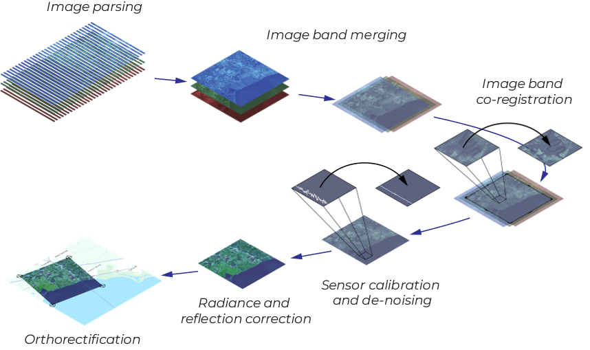
How Unibap LOOM Works
Unibap LOOM is all about changing this. At its core, LOOM is a data pre-processing pipeline that takes raw data and converts it into a much more refined data product. And it does it fast. On our iX10, it’s possible to transform raw multispectral data into orthorectified satellite images in real time! Here’s how we do it:
Thus, the output from Unibap LOOM is no longer raw data, but a fully refined satellite image that can be downlinked to the ground or fed into an on-board neural network for further analysis at the same rate as it is acquired from the sensor. 100% utilization.
Commercial Implications
The commercial implications of this are immense. A typical satellite image often covers hundreds of square kilometres, but its end-user usually needs only a fraction of that area. The rest essentially worthless, yet it costs just as much to downlink. With Unibap LOOM, you can allow your customers to choose exactly what information they want to pay for, crop it out in space, and only send the valuable snippets down to the ground. And that’s not all – you can also use AI to verify that the collected information meets your customers’ expectations, for example, by removing all images where the area of interest is covered by clouds. Suddenly, you can downlink much less data or serve many more customers , scaling your business model exponentially.
The Revolution is Here
Unibap LOOM lets you serve more customers with better data products at a lower cost, and for the first time fully utilize your space assets. That’s how edge computing will revolutionize the commercial Earth observation market.
/Anders Persson
Product Manager, Unibap